Liste des parcs nationaux d'Australie-Occidentale
Les parcs nationaux d'Australie-Occidentale sont au nombre de quatre-vingt-dix-huit et couvrent une superficie de 56 680,65 km2[1]. Ils sont gérés par le ministère de l'Environnement et de la Conservation d'Australie-Occidentale.
Localisation des principaux parcs nationaux
|
Liste des parcs
- Parc appartenant au patrimoine mondial de l'UNESCO
- Parc appartenant à une réserve de biosphère de l'UNESCO
- Parc appartenant à un site Ramsar
| Nom[1] | Photographie | Localisation | Création | Superficie km2 |
Notes |
|---|---|---|---|---|---|
| Alexander Morrison |  |
Mid West 30° 05′ 02″ S, 115° 29′ 10″ E |
1970 | 85,00 | |
| Avon Valley |  |
Wheatbelt 31° 37′ 30″ S, 116° 11′ 01″ E |
1970 | 43,66 | |
| Badgingarra |  |
Wheatbelt 30° 28′ 07″ S, 115° 26′ 23″ E |
1973 | 131,08 | |
| Beedelup |  |
South West 34° 25′ 06″ S, 115° 52′ 40″ E |
1977 | 193,79 | |
| Beelu |  |
Perth 31° 57′ 16″ S, 116° 08′ 59″ E |
1995 | 46,17 | |
| Blackwood River | |
South West 34° 04′ 35″ S, 115° 23′ 20″ E |
2004 | 204,77 | |
| Boorabbin |  |
Goldfields-Esperance 31° 14′ 18″ S, 120° 10′ 09″ E |
1977 | 281,53 | |
| Boorara Gardner | |
South West 34° 44′ S, 116° 13′ E |
2004 | 110,08 | |
| Boyndaminup | |
South West 34° 28′ S, 116° 34′ E |
2004 | 54,39 | |
| Bramley | |
South West 33° 56′ S, 115° 07′ E |
2004 | 38,92 | |
| Brockman | |
South West 34° 30′ 52″ S, 115° 59′ 46″ E |
1977 | 0,52 | |
| Cap Arid (Cape Arid) |  |
Goldfields-Esperance 33° 42′ 14″ S, 123° 22′ 10″ E |
1969 | 2 794,46 | |
| Cap Le Grand (Cape Le Grand) |  |
Goldfields-Esperance 33° 56′ 49″ S, 122° 00′ 20″ E |
1966 | 318,01 | |
| Chaîne du Cap (Cape Range) |  |
Gascoyne 22° 07′ 25″ S, 113° 54′ 59″ E |
1965 | 476,55 | Site du patrimoine mondial de la côte de Ningaloo (2011)[2] |
| Chaîne Collier (Collier Range) | |
Pilbara 24° 27′ 35″ S, 119° 09′ 25″ E |
1978 | 476,55 | |
| Chaîne Kennedy (Kennedy Range) | |
Gascoyne 24° 34′ 45″ S, 115° 02′ 59″ E |
1993 | 1 416,60 | |
| Chaîne de Stirling (Stirling Range) |  |
Great Southern 34° 21′ 50″ S, 117° 59′ 20″ E |
1969 | 1 159,20 | |
| D’Entrecasteaux |  |
South West 34° 21′ 50″ S, 117° 59′ 20″ E |
1980 | 1 187,79 | |
| Dalgarup | |
South West 33° 59′ 08″ S, 115° 58′ 36″ E |
2004 | 23,77 | |
| Drovers Cave | |
Wheatbelt 30° 14′ 04″ S, 115° 05′ 16″ E |
1972 | 26,81 | |
| Drysdale River | |
Kimberley 15° 09′ 41″ S, 126° 46′ 35″ E |
1974 | 4 482,64 | |
| Easter | |
South West 34° 13′ S, 115° 47′ E |
2004 | 29,85 | |
| Eucla |  |
Goldfields-Esperance 31° 40′ 49″ S, 128° 56′ 43″ E |
35,60 | ||
| Fitzgerald River |  |
Goldfields-Esperance 33° 56′ 51″ S, 119° 36′ 55″ E |
1973 | 2 972,11 | Réserve de biosphère de Fitzgerald River (1978)[3] |
| Forest Grove | |
South West 34° 05′ S, 115° 08′ E |
2004 | 13,79 | |
| François Péron (Francois Peron) |  |
Gascoyne 25° 48′ 10″ S, 113° 32′ 38″ E |
1993 | 525,87 | Site du patrimoine mondial de la baie Shark (1991)[4] |
| Frank Hann | |
Gascoyne 32° 55′ 41″ S, 120° 14′ 14″ E |
1970 | 675,50 | |
| Geikie Gorge |  |
Kimberley 18° 11′ 40″ S, 125° 34′ 08″ E |
1967 | 31,36 | |
| Gloucester |  |
South West 34° 26′ 52″ S, 116° 03′ 27″ E |
1993 | 8,78 | |
| Goldfields Woodlands | |
Goldfields-Esperance 31° 11′ 00″ S, 120° 33′ 09″ E |
1977 | 646,12 | |
| Goongarrie | |
Goldfields-Esperance 30° 00′ 08″ S, 121° 31′ 51″ E |
1978 | 603,97 | |
| Gooseberry Hill |  |
Perth 31° 56′ 29″ S, 116° 02′ 47″ E |
1970 | 0,33 | |
| Greater Dordagup | |
South West 34° 31′ S, 116° 17′ E |
2004 | 64,08 | |
| Greater Hawke | |
South West 34° 31′ S, 115° 52′ E |
2004 | 140,04 | |
| Greater Kingston | |
South West 34° 07′ S, 116° 38′ E |
210,92 | ||
| Greater Preston | |
South West 33° 35′ 53″ S, 116° 13′ 15″ E |
2004 | 126,65 | |
| Greenmount |  |
South West 31° 54′ 23″ S, 116° 03′ 36″ E |
1970 | 2,02 | |
| Gull Rock |  |
Great Southern 35° 00′ 27″ S, 118° 00′ 12″ E |
2006 | 21,04 | |
| Hassell | |
Great Southern 34° 40′ 44″ S, 118° 22′ 11″ E |
1971 | 12,65 | |
| Helena |  |
Perth 32° 06′ 23″ S, 116° 11′ 38″ E |
1995 | 122,55 | |
| Hilliger | |
South West 34° 15′ S, 115° 40′ E |
169,62 | ||
| Île Dirk Hartog (Dirk Hartog Island) | |
Gascoyne 25° 49′ 13″ S, 113° 04′ 46″ E |
2009 | 629,28 | Site du patrimoine mondial de la baie Shark (1991)[4] |
| Jane | |
South West 34° 36′ S, 116° 15′ E |
2004 | 68,63 | |
| John Forrest |  |
Perth 31° 52′ 55″ S, 116° 04′ 26″ E |
1900 | 26,78 | |
| Kalamunda | |
Perth 31° 57′ 31″ S, 116° 04′ 17″ E |
1964 | 3,75 | |
| Kalbarri |  |
Mid West 27° 42′ 47″ S, 114° 10′ 01″ E |
1963 | 1 830,05 | |
| Karijini |  |
Pilbara 22° 40′ 21″ S, 118° 12′ 52″ E |
1969 | 6 274,42 | |
| Karlamilyi | |
Pilbara 22° 20′ 00″ S, 122° 29′ 00″ E |
1977 | 12 837,06 | |
| Korung | |
Perth 32° 03′ 28″ S, 116° 05′ 41″ E |
63,44 | ||
| Lac Muir (Lake Muir) |  |
South West 34° 33′ S, 116° 40′ E |
2004 | 96,25 | Site Ramsar du système Muir-Byenup (2005)[5] |
| Lawley River | |
Kimberley 14° 41′ S, 125° 53′ E |
2000 | 175,72 | |
| Leeuwin-Naturaliste |  |
South West 34° 14′ 19″ S, 115° 02′ 50″ E |
1957 | 190,92 | |
| Lesmurdie Falls |  |
Perth 31° 59′ 47″ S, 116° 01′ 49″ E |
1957 | 0,56 | |
| Lesueur |  |
Wheatbelt 30° 08′ 04″ S, 115° 06′ 02″ E |
1992 | 2 699 | |
| Midgegooroo |  |
Perth 32° 07′ 40″ S, 116° 07′ 50″ E |
2004 | 24,92 | |
| Millstream-Chichester |  |
Pilbara 32° 07′ 40″ S, 116° 07′ 50″ E |
1970 | 2 381,67 | |
| Milyeannup | |
South West 21° 16′ 24″ S, 117° 06′ 27″ E |
2004 | 186,92 | |
| Mirima | |
Kimberley 15° 46′ 23″ S, 128° 45′ 46″ E |
1982 | 20,68 | |
| Mitchell River |  |
Kimberley 14° 48′ 24″ S, 125° 42′ 29″ E |
2000 | 1 153,25 | |
| Mont Augustus (Mount Augustus) | 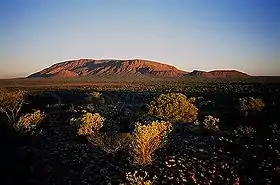 |
Pilbara 24° 19′ 50″ S, 116° 50′ 37″ E |
1989 | 91,68 | |
| Mont Frankland (Mount Frankland) | |
South West 34° 45′ 59″ S, 116° 44′ 34″ E |
1989 | 172,54 | |
| Mont Frankland Nord (Mount Frankland North) | |
South West 34° 39′ S, 116° 42′ E |
2004 | 220,53 | |
| Mont Frankland Sud (Mount Frankland South) | |
South West 34° 56′ 00″ S, 116° 40′ 00″ E |
2004 | 422,83 | |
| Mont Lindesay (Mount Lindesay) | |
Great Southern 34° 52′ 00″ S, 117° 22′ 00″ E |
2004 | 395,41 | |
| Mont Roe (Mount Roe) | |
Great Southern 34° 46′ 00″ S, 116° 56′ 00″ E |
2004 | 1 277,26 | |
| Moore River | |
Wheatbelt 31° 05′ 00″ S, 115° 38′ 00″ E |
1988 | 91,68 | |
| Nambung | 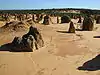 |
Wheatbelt 30° 34′ 33″ S, 115° 10′ 12″ E |
1968 | 192,68 | |
| Neerabup | |
Perth 31° 40′ 30″ S, 115° 44′ 07″ E |
1965 | 9,43 | |
| Peak Charles | |
Goldfields-Esperance 32° 54′ 35″ S, 121° 06′ 24″ E |
1979 | 399,59 | |
| Porongurup | Great Southern 34° 40′ 46″ S, 117° 52′ 23″ E |
1971 | 26,21 | ||
| Purnululu | 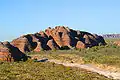 |
Kimberley 34° 40′ 46″ S, 117° 52′ 23″ E |
1987 | 2 397,23 | Site du patrimoine mondial du parc national de Purnululu (2003)[6] |
| Scott | |
South West 34° 15′ 29″ S, 115° 14′ 08″ E |
1959 | 32,73 | |
| Serpentine |  |
Perth 32° 21′ 26″ S, 116° 02′ 36″ E |
1957 | 43,87 | |
| Shannon | |
South West 34° 36′ 11″ S, 116° 21′ 54″ E |
1988 | 525,98 | |
| Sir James Mitchell | |
South West 34° 23′ S, 116° 11′ E |
1969 | 2,47 | |
| Stokes | |
Goldfields-Esperance 33° 49′ 22″ S, 121° 08′ 05″ E |
1976 | 97,26 | |
| Tathra | |
Wheatbelt 29° 46′ 37″ S, 115° 31′ 44″ E |
1970 | 43,22 | |
| Torndirrup |  |
Great Southern 35° 05′ 25″ S, 117° 53′ 29″ E |
1918 | 39,36 | |
| Tuart Forest | |
South West 33° 33′ 07″ S, 115° 30′ 43″ E |
1987 | 20,49 | |
| Tunnel Creek |  |
Kimberley 17° 36′ 43″ S, 125° 08′ 34″ E |
1992 | 0,91 | |
| Walpole-Nornalup |  |
South West 34° 59′ 00″ S, 116° 46′ 00″ E |
1957 | 194,48 | |
| Walyunga | |
Perth 31° 42′ 22″ S, 116° 05′ 23″ E |
1970 | 18,14 | |
| Wandoo | |
Wheatbelt 31° 59′ S, 116° 34′ E |
1995 | 464,93 | |
| Warren | |
South West 34° 30′ 02″ S, 115° 57′ 22″ E |
1977 | 29,81 | |
| Watheroo | |
Wheatbelt 30° 14′ 24″ S, 115° 52′ 43″ E |
1969 | 444,81 | |
| Waychinicup |  |
Great Southern 34° 52′ 38″ S, 118° 22′ 20″ E |
1990 | 39,82 | |
| Wellington | |
South West 33° 22′ S, 115° 57′ E |
2000 | 174,20 | |
| West Cape Howe | |
Great Southern 35° 06′ 22″ S, 117° 35′ 34″ E |
1985 | 36,05 | |
| Whicher | |
South West 33° 56′ S, 115° 29′ E |
2004 | 17,34 | |
| William Bay | 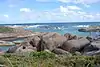 |
Great Southern 35° 01′ 35″ S, 117° 14′ 06″ E |
1971 | 17,34 | |
| Wiltshire-Butler | |
South West 33° 56′ S, 115° 29′ E |
116,45 | ||
| Windjana Gorge |  |
Kimberley 17° 25′ 42″ S, 124° 58′ 35″ E |
1971 | 20,50 | |
| Wolfe Creek Meteorite Crater |  |
Kimberley 19° 10′ 19″ S, 127° 47′ 43″ E |
1969 | 14,60 | |
| Yalgorup |  |
Peel 32° 51′ 26″ S, 115° 40′ 19″ E |
1966 | 131,41 | Site Ramsar du système Peel-Yalgorup (1990)[5] |
| Yanchep |  |
Perth 31° 33′ 38″ S, 115° 41′ 27″ E |
1957 | 28,76 | |
| Yelverton | |
South West 33° 44′ S, 115° 05′ E |
2004 | 7,29 |
De plus l'Australie-Occidentale possède deux parcs nationaux innomés de 1 571 et de 79 ha[1].
Voir aussi
Notes et références
- (en) Department of Environment and Conservation, 2009 – 10 Annual Report, , 119 p. (ISSN 1835-114X, lire en ligne), p. 48
- « Côte de Ningaloo », sur UNESCO Centre du patrimoine mondial (consulté le )
- « Fitzgerald River », sur MAB Biosphere Reserve Directory (consulté le )
- « Baie Shark, Australie occidentale », sur UNESCO Centre du patrimoine mondial (consulté le )
- (en) « The Annotated Ramsar List: Australia », sur Convention de Ramsar (consulté le )
- « Parc national de Purnululu », sur UNESCO Centre du patrimoine mondial (consulté le )
 Portail de la conservation de la nature
  Portail de l’Australie-Occidentale
Cet article est issu de Wikipedia. Le texte est sous licence Creative Commons - Attribution - Partage dans les Mêmes. Des conditions supplémentaires peuvent s'appliquer aux fichiers multimédias.