Arrondissement de Spree-Neisse

L'arrondissement de Spree-Neisse est un arrondissement ("Landkreis" en allemand) du Brandebourg (Allemagne). Son chef-lieu est Forst (Lausitz).

Arrondissement de Spree-Neisse
Landkreis Spree-Neiße

Héraldique

Localisation
Administration
Pays Allemagne
Land Brandebourg
Chef-lieu Forst (Lausitz)
Villes principales Forst (Lausitz),
Guben,
Spremberg.
Préfet
(Landrat)
Harald Altekrüger
Partis au pouvoir CDU
Code arrondissemental
(Kreisschlüssel)
12 0 71
Immatriculation SPN, FOR, GUB, SPB
Communes 30
Démographie
Population 114 429 hab. (31 décembre 2018)
Densité 69 hab./km2
Géographie
Superficie 1 647,89 km2
Localisation
Liens
Site web www.landkreis-spree-neisse.de

    Villes, communes & communautés d'administration

    (nombre d'habitants au 31 décembre 2017)

    Villes non liées à un Amt

    1. Drebkau ↔ Drjowk (5 580)
    2. Forst (Lausitz) ↔ Baršć (18 353)
    3. Guben ↔ Gubin (17 174)
    4. Spremberg ↔ Grodk (22 456)
    5. Welzow ↔ Wjelcej (3 490)

    Communes non liées à un Amt

    1. Kolkwitz ↔ Gołkojce (9 189)
    2. Neuhausen/Spree ↔ Kopanće/Sprjewja (4 935)
    3. Schenkendöbern (3 613)

    Ämter et communes liées

    1. Burg (Spreewald) ↔ Borkowy (Błota) (9 026)
      1. Briesen ↔ Brjazyna (763)
      2. Burg (Spreewald) ↔ Borkowy (Błota) (4 276)
      3. Dissen-Striesow ↔ Dešno-Strjažow (984)
      4. Guhrow ↔ Gory (521)
      5. Schmogrow-Fehrow ↔ Smogorjow-Prjawoz (789)
      6. Werben ↔ Wjerbno (1 693)
    2. Döbern-Land ↔ Derbno-kraj (10 890)
      1. Döbern ↔ Derbno, Stadt (3 250)
      2. Felixsee ↔ Feliksowy jazor (1 898)
      3. Groß Schacksdorf-Simmersdorf ↔ Tšěšojce-Žymjerojce (1 025)
      4. Jämlitz-Klein Düben ↔ Jemjelica-Źěwink (468)
      5. Neiße-Malxetal ↔ Dolina Nysa-Małksa (1 624)
      6. Tschernitz ↔ Cersk (1 239)
      7. Wiesengrund ↔ Łukojce (1 386)
    3. Peitz ↔ Picnjo (10 750)
      1. Drachhausen ↔ Hochoza (800)
      2. Drehnow ↔ Drjenow (521)
      3. Heinersbrück ↔ Most (573)
      4. Jänschwalde ↔ Janšojce (1 537)
      5. Peitz ↔ Picnjo, Stadt (4 362)
      6. Tauer ↔ Turjej (694)
      7. Teichland ↔ Gatojce (1 118)
      8. Turnow-Preilack ↔ Turnow-Pśiłuk (1 145)

    Démographie

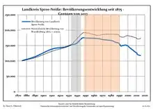
    Évolution de la population dans les limites actuelles (2013). Ligne bleue: Population -- Ligne pointillé: Comparaison avec le développement de Brandebourg Fond gris: Période du régime nazie -- Fond rouge: Période du régime communiste
    Landkreis Spree-Neiße:
    Évolution de la population dans les limites de 2013
    [1].
    Année Population
    1875101 025
    1890113 766
    1910138 428
    1925144 789
    1933152 241
    1939156 827
    1946174 693
    1950174 606
    1964172 833
    1971169 325
    Année Population
    1981165 870
    1985161 288
    1989158 063
    1990154 926
    1991150 875
    1992148 339
    1993149 606
    1994150 024
    1995150 364
    1996151 279
    Année Population
    1997151 830
    1998151 016
    1999150 171
    2000148 700
    2001145 929
    2002143 642
    2003141 256
    2004139 464
    2005136 896
    2006135 017
    Année Population
    2007132 798
    2008130 626
    2009128 470
    2010126 400
    2011121 571
    2012120 178
    2013118 899


    Notes et références

    1. Les sources de données se trouvent en detail dans les Wikimedia Commons Population Projection Brandenburg at Wikimedia Commons
    • Portail du Brandebourg
    Cet article est issu de Wikipedia. Le texte est sous licence Creative Commons - Attribution - Partage dans les Mêmes. Des conditions supplémentaires peuvent s'appliquer aux fichiers multimédias.