Arrondissement de Rottal-Inn
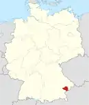
L'arrondissement de Rottal-Inn est un arrondissement (Landkreis en allemand) de Bavière (Allemagne) situé dans le district (Regierungsbezirk en allemand) de Basse-Bavière. Son chef lieu est Pfarrkirchen.
| Arrondissement de Rottal-Inn Landkreis Rottal-Inn | |
 Héraldique |
 Localisation |
| Administration | |
|---|---|
| Pays | |
| Land | |
| District (Regierungsbezirk) |
Basse-Bavière |
| Chef-lieu | Pfarrkirchen |
| Villes principales | Eggenfelden, Pfarrkirchen |
| Préfet (Landrat) |
Michael Fahmüller |
| Partis au pouvoir | CSU |
| Code arrondissemental (Kreisschlüssel) |
09 2 77 |
| Immatriculation | EG, GRI, PAN, VIB |
| Communes | 31 |
| Démographie | |
| Population | 117 952 hab. (31 décembre 2010) |
| Densité | 92 hab./km2 |
| Géographie | |
| Superficie | 1 280 km2 |
| Localisation | |

| |
| Liens | |
| Site web | www.rottal-inn.de |
Villes, communes & communautés d'administration
(nombre d'habitants en 2006)
|
Pas de Gemeindefreie Gebiete |

.svg.png.webp) Portail de la Bavière
Portail de la Bavière
Cet article est issu de Wikipedia. Le texte est sous licence Creative Commons - Attribution - Partage dans les Mêmes. Des conditions supplémentaires peuvent s'appliquer aux fichiers multimédias.