Province ignée nord-atlantique
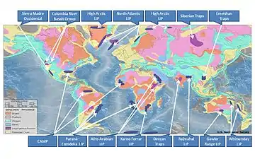
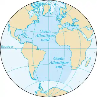
La province ignée nord-atlantique (acronyme en anglais : NAIP[note 1]) est une grande province ignée qui couvre une surface estimée à 1,3 million de kilomètres carrés et dont le volume est estimé à 6,6 millions de kilomètres cubes[1]. Géographiquement, elle couvre l’ensemble du nord de l’océan Atlantique, comprenant les basaltes éocènes et paléocènes du Groenland, d’Islande, du Royaume-Uni, du Danemark, de la Norvège ainsi que d’une bonne partie des îles localisées dans la partie nord-est de l’océan atlantique[2],[3].
Description
La datation radiométrique indique que la période magmatique la plus active de la NAIP se situe entre 60,5 et 54,5 millions d’années (Ma)[4] (du Paléocène moyen à l’Eocène inférieur). Elle est divisée en une Phase 1 (62-58 Ma, phase de pré-ouverture) et une Phase 2 (56-54 Ma, phase d’ouverture)[5].
Des recherches en cours tendent à montrer que les mouvements plaques tectoniques concernées, eurasiatique, groenlandaise et nord-américaine, les phénomènes de « rifting » et l’expansion des fonds océaniques entre le Labrador et le Groenland pourraient avoir débuté dès 95-80 Ma environ[6], vers 80 Ma[7], et vers 63-61 Ma[8],[9] respectivement (de fin Crétacé à début du Paléocène).
La formation de la NAIP peut aussi être mise en relation avec le point chaud/panache islandais. En s’appuyant sur les analyses géochimiques et les observations et reconstructions paléogéographiques, l’hypothèse est avancée que l’actuel point chaud islandais soit issu d’un panache mantellique de la Dorsale Alpha (océan Arctique) aux alentours de 130-120 Ma[10], qu’il a migré au sud (migrated down) de l’île d'Ellesmere, au travers de l’île de Baffin, par la côte ouest du Groenland pour finir par être positionné sur sa côte est vers 60 Ma[11].
L’actuel point chaud islandais comme celui de Jan Mayen, tout comme la partie nord de la Dorsale médio-atlantique sont géologiquement actifs.
La NAIP est constituée de coulées basaltiques, terrestres ou sous-marines, de sills, dykes et plateaux. Les basaltes les constituant sont de type MORB[12],[note 2], alcalins[13],[14], de tholéiites et de picrites[15].
Synonymes et/ou désignations apparentées
- Brito-Arctic province (BAP)
- North Atlantic Tertiary Province (NATP)
- North Atlantic Volcanic Province (NAVP)
- North Atlantic Basalt Province (NABP)
- North Atlantic Tertiary Volcanic Province (NATVP)
- British Tertiary Igneous Province (BTIP)
- British Tertiary Volcanic Province (BTVP)
- British Paleogene Igneous Province (BPIP)
- Thulean Plateau
Notes et références
Notes
- NAIP pour « North Atlantic Ignaceous Province »
- MORB, acronyme anglais pour « Mid Ocean Ridge Basalt ».
Références
- Olav Eldholm, « North Atlantic volcanic margins: Dimensions and production rates », Journal of Geophysical Research: Solid Earth, vol. 99, no B2, , p. 2955–2968 (DOI 10.1029/93JB02879, lire en ligne) :
« Quantitative calculations of NAVP dimensions, considered minimum estimates, reveal an areal extent of 1.3×10⁶ km2 and a volume of flood basalts of 1.8×10⁶ km3, yielding a mean eruption rate of 0.6 km3/yr or 2.4 km3/yr if two-thirds of the basalts were emplaced within 0.5 m.y. The total crustal volume is 6.6×10⁶ km3, resulting in a mean crustal accretion rate of 2.2 km3/yr. Thus NAVP ranks among the world's larger igneous provinces if the volcanic margins are considered. »
- (en) The North Atlantic igneous province stratigraphy, tectonic, volcanic, and magmatic processes, London, D.W. Jolley, B.R. Bell, (ISBN 1-86239-108-4, lire en ligne)
- Vincent Courtillot, « On the ages of flood basalt events », Comptes Rendus Geoscience, vol. 335, no 1, , p. 113–140 (DOI 10.1016/S1631-0713(03)00006-3, lire en ligne) :
« From file page 7 onward: Brito-Arctic Province section (section also discusses age, pulses of activity, and volume) »
- D. W. Jolley, « The evolution of the North Atlantic Igneous Province and the opening of the NE Atlantic rift », Geological Society, London, Special Publications, vol. 197, no 1, , p. 1–13 (DOI 10.1144/GSL.SP.2002.197.01.01, lire en ligne) :
« 40Ar/39Ar and Pb-U isotopic age data show that the main period of continental flood basalt volcanism in the NAIP extended from ~60.5 Ma through to ~54.5 Ma. »
- S. Rousse, « The British Tertiary Volcanics: Origin, History and New Paleogeographic Constraints for the North Atlantic », Geophysical Research Abstracts, vol. 9, (lire en ligne) :
« The NAIP formed during two major magmatic phases: a pre-break-up phase (62-58 Ma) and a syn-break-up phase (56-54 Ma) contemporaneous with the onset of North Atlantic sea floor spreading. »
- T.H. Torsvik, « North Atlantic Plate Motions and Plumes », Geophysical Research Abstracts, vol. 9, (lire en ligne) :
« Fixed hotspot frames show uniform NE movement of the coupled North American, Greenland, and Eurasian plates from ~95 to 80 Ma. »
- Jan Inge Faleide, « Structure and evolution of the continental margin off Norway and the Barents Sea », Episodes, vol. 31, no 1, , p. 82 (lire en ligne) :
« Breakup in the NE Atlantic was preceded by prominent Late Cretaceous-Paleocene rifting. At the onset of this rifting, the area between NW Europe and Greenland was an epicontinental sea covering a region in which the crust had been extensively weakened by previous rift episodes. Ren et al. (2003) suggested onset of rifting at about 81 Ma »
- Lotte Melchior Larsen, « 40Ar/39Ar Dating of Alkali Basaltic Dykes along the Southwest Coast of Greenland: Cretaceous and Tertiary Igneous Activity along the Eastern Margin of the Labrador Sea », Geology of Greenland Survey Bulletin, no 184, , p. 19-29 (lire en ligne) :
« The start of normal velocity ocean floor spreading in the Labrador Sea took place in the Paleocene, around geomagnetic chrons C27-C28 (61-63 Ma) and was accompanied by a burst in volcanic activity, where large amounts of tholeiitic picrites and basalts were erupted onto the continental margins of West Greenland and Labrador »
- J. A. Chalmers, « Development of the continental margins of the Labrador Sea: a review », Geological Society, London, Special Publications, vol. 187, no 1, , p. 77–105 (DOI 10.1144/GSL.SP.2001.187.01.05) :
« The Labrador Sea is a small oceanic basin that developed when the North American and Greenland plates separated. An initial period of stretching in Early Cretaceous time formed sedimentary basins now preserved under the continental shelves and around the margins of the oceanic crust. The basins subsided thermally during Late Cretaceous time and a second episode of tectonism took place during latest Cretaceous and early Paleocene time, before the onset of sea-floor spreading in mid-Paleocene time. »
- A.D. Saunders, « Tracking the Iceland Plume across the Arctic Ocean », Geophysical Research Abstracts, vol. 7, (lire en ligne) :
« It is widely assumed that Iceland sits above a mantle plume or hotspot. This plume has been tracked back to about 60 Ma, when it resided beneath Greenland. We explore the alternative possibility that the plume existed long before 60 Ma and was responsible for volcanic activity in northern Canada, beneath the Arctic Ocean, and across the Barents Shelf and in Siberia. Plate reconstructions place the plume beneath what is now northeastern Canada at about 80 Ma. This correlates with an episode of basaltic volcanism in the Queen Elizabeth Islands, dated at around 90 Ma. The aseismic Alpha Ridge is bathymetrically linked to northern Ellesmere Island, and extends northwards beneath the Arctic Ocean. »
- C Tegner, « 40Ar/39Ar geochronology of Tertiary mafic intrusions along the East Greenland rifted margin: Relation to flood basalts and the Iceland hotspot track », Earth and Planetary Science Letters, vol. 156, nos 1-2, , p. 75–88 (DOI 10.1016/S0012-821X(97)00206-9) :
« The East Greenland Tertiary Igneous Province includes the largest exposed continental flood basalt sequence within the North Atlantic borderlands. Plate-kinematic models indicate the axis of the ancestral Iceland mantle plume was located under Central Greenland at ~60 Ma and subsequently crossed the East Greenland rifted continental margin. »
- Chr. Robert et R. Bousquet, Géosciences, la dynamique du système Terre, 2013, p. 637.
- J. Tarney, « Nature of Mantle Heterogeneity in the North Atlantic: Evidence from Deep Sea Drilling », Philosophical Transactions of the Royal Society A: Mathematical, Physical and Engineering Sciences, vol. 297, no 1431, , p. 179–202 (DOI 10.1098/rsta.1980.0209) :
« Studies of dredged and drilled samples from the North Atlantic ocean have revealed that basalts with a wide range of major and trace element compositions have been generated at the Mid-Atlantic Ridge. Drilling along mantle flow lines transverse to the ridge has shown that different segments of the MAR have produced basalts with a distinct compositional range for tens of millions of years. »
- L. E. Heister, « Pyroclastic deposits within the East Greenland Tertiary flood basalts », Journal of the Geological Society, vol. 158, no 2, , p. 269–284 (DOI 10.1144/jgs.158.2.269) :
« Stratigraphic, geochemical and mineralogical characterization of pyroclastic deposits on the Gronau West Nunatak of East Greenland indicates that both alkaline and basaltic tephras occurred during the eruption of flood basalts associated with the opening of the North Atlantic ocean in the early Tertiary. »
- C. K. Brooks, « The Blosseville Coast basalts of East Greenland: Their occurrence, composition and temporal variations », Contributions to Mineralogy and Petrology, vol. 58, no 3, , p. 279–292 (DOI 10.1007/BF00402356) :
« Major and trace element compositions are presented for basalts from the area between Kangerdlugssuaq and Scoresby Sund, East Greenland. The bulk of these lavas have a very uniform composition and are tholeiites... The only significant variation is minor and represents a change to a more evolved type to the south, a variation which may be similar to that observed in Postglacial Icelandic lavas. The earliest lavas are of a picritic type… »
Sources
- (en) Cet article est partiellement ou en totalité issu de l’article de Wikipédia en anglais intitulé « North Atlantic Igneous Province » (voir la liste des auteurs).
Voir aussi
Bibliographie
![]() : document utilisé comme source pour la rédaction de cet article.
: document utilisé comme source pour la rédaction de cet article.
- Christian Robert et Romain Bousquet (dir.) (préf. Xavier Le Pichon), Géosciences : La dynamique du système Terre, Paris, Belin, , 1159 p. (ISBN 978-2-7011-3816-9)

- JM Caron, A Gauthier, JM Lardeaux, A Schaaf, J Ulysse et J Wozniak, Comprendre et enseigner la planète Terre, Gap, Ophrys, , 303 p. (ISBN 2-7080-1021-2, notice BnF no FRBNF39078219)
Articles connexes
Liens externes
- Carte du NAIP - par R. W. Kent, « Mantle Sources and Melting Dynamics in the British Palaeogene Igneous Province », Journal of Petrology, vol. 41, no 7, , p. 1023–1040 (DOI 10.1093/petrology/41.7.1023, lire en ligne)
- Carte paléobiogéographique du NAIP - par R. M. Ellam, « The Sub-lithospheric Source of North Atlantic Basalts: Evidence for, and Significance of, a Common End-member », Journal of Petrology, vol. 41, no 7, , p. 919–932 (DOI 10.1093/petrology/41.7.919, lire en ligne)
- Panaches mantelliques - Iceland Hotspot page
- « Large Igneous Province Commission - Accueil »(Archive • Wikiwix • Archive.is • Google • Que faire ?) (consulté le )
 Portail de l’océan Atlantique
  Portail du volcanisme