Emanuel Bowen
Emanuel Bowen (1694 - 1767) est un graveur de carte géographique, éditeur et marchand d'estampes gallois.
Il a obtenu la distinction unique de devenir cartographe royal à la fois pour le roi George II d'Angleterre et Louis XV de France[1],[2]. Bowen est très apprécié par ses contemporains pour avoir produit certaines des cartes les plus grandes, les plus détaillées et les plus précises de son époque.
Biographie
Emanuel Bowen est né en 1694 à Tal-y-Llychau (en), dans le Carmarthenshire, au pays de Galles[3]. Il est le fils d'Owen Bowen (mort en 1730) et de son épouse Anne (morte en 1721)[4].
En 1709, Bowen devient l'apprenti de Charles Price, fabricant de globe planétaire et d'instrument de cartographie[4].
Il s'installe à Londres vers 1714[5].
En 1726, il est considéré comme l'un des principaux graveurs de cartes de Londres[3]. Parmi ses multiples apprentis, les plus notables sont Thomas Kitchin, Thomas Jefferys (en), John Lodge[Lequel ?] et son fils Thomas Bowen (en). Un autre apprenti, John Oakman (en), qui a eu une liaison avec la fille de Bowen et qui l'a finalement mariée[6] ; Thomas Kitchin a lui aussi épousé une fille de Bowen, Sarah[3].
Emanuel Bowen meurt en 1767[7].
Œuvre
_Empire_1747.jpg.webp)
.jpg.webp)
Emanuel Bowen a édité de nombreuses cartes géographiques, dont certaines sont conservées à la Bibliothèque nationale de France[7].
On connaît de lui les ouvrages suivants :
- Britannia Depicta, 1720[9]
- A complete system of geography being a description of all the countries, islands, cities, chief towns... of the known world[9] ou Complete Atlas of Geography, 1744-1747[1]
- English Atlas, with a new set of maps, c. 1745[1]
- Complete System of Geography, 1747[10]
- Mariner’s Compass and Armillary Sphere, 1748[11]
- Complete Atlas … in sixty-eight Maps, 1752[1]
- A new dictionary of trade and commerce, 1756[12]
- Atlas Minimus; or a new set of Pocket Maps, 1758[1]
- The Royal English atlas : eighteenth century county maps of England and Wales, 1763[13]
Ainsi que de nombreuses cartes séparées dont :
- Série de cartes séparées des comtés d'Angleterre, de l'Allemagne, de l'Asie mineure et de Perse (1736-1776)[1]
- Map of Iran in Afsharid dynasty (1747), c. 1750[5]
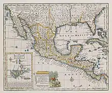
- A New & Accurate Map of Mexico or New Spain together with California, New Mexico &c, 1752[8]
- A map of the British American plantations : extending from Boston in New England to Georgia, publiée dans Gentleman's Magazine (1754)[14]
Notes et références
- Dictionary of National Biography, 1886.
- (en) Samuel Redgrave, « Bowen, Emanuel », dans Dictionary of Artists of the English School, G. Bell, (lire en ligne), p. 50.
- (en) « #LoveMaps – Mary-Ann Constantine », sur Bibliothèque nationale du pays de Galles (consulté le ).
- (en) « Notice biographique », sur Oxford Dictionary of National Biography (consulté le ).
- (en) « Notice d'Emanuel Bowen », sur Stuttgart Database of Scientific Illustrators 1450–1950 (en) (consulté le ).
- (en) Lionel Henry Cust, « Oakman, John », dans Dictionary of National Biography, vol. 41, (lire sur Wikisource), p. 292.
- « Notice d'Emanuel Bowen », sur data.bnf.fr (consulté le ).
- Huseman 2016, p. 37.
- (en) « Emanuel Bowen », sur Open Library (consulté le ).
- (en) J. M. Wordie et al., « An Expedition to North West Greenland and the Canadian Arctic in 1937 », The Geographical Journal, vol. 92, no 5, , p. 385–418 (JSTOR 1788049).
- (en) « 1748 Bowen Mariner’s Compass and Armillary Sphere », sur geographicus.com (consulté le ).
- (en) Richard Bolt, Emanuel Bowen et Samuel Johnson, A new dictionary of trade and commerce : compiled from the information of the most eminent merchants, and from the works of the best writers on commercial subjects, in all languages ... for the use of the merchants and tradesmen of Great Britain, as well as of private gentlemen, Londres, Printed for G. Keith [and 3 others], 1761 [1756], 908 p. (OCLC 65354634).
- (en) Emanuel Bowen et Thomas Kitchin, The Royal English atlas : eighteenth century county maps of England and Wales, Newton Abbot, David & Charles, (ISBN 9780715351000, OCLC 299407074).
- (en) Emanuel Bowen et Thomas Bowen, « A map of the British American plantations : extending from Boston in New England to Georgia ; including all the back settlements in the respective provinces, as far as the Mississippi ; by Eman. Bowen Geogr. to His Majesty ; Tho. Bowen Sc. », Gentleman's Magazine, Londres, , p. 322 (OCLC 240893808).
Annexes
Bibliographie
- (en) Sidney Lee, « Bowen, Thomas », dans Dictionary of National Biography, vol. 6, (lire sur Wikisource), p. 48.
- (en) Ben W. Huseman, Enlightenment Mapmakers and the Southwest Borderlands, Arlington, The University of Texas at Arlington Libraries, .
Liens externes
- Notices d'autorité :
- Fichier d’autorité international virtuel
- International Standard Name Identifier
- Bibliothèque nationale de France (données)
- Système universitaire de documentation
- Bibliothèque du Congrès
- Gemeinsame Normdatei
- Bibliothèque royale des Pays-Bas
- Bibliothèque nationale de Pologne
- Bibliothèque universitaire de Pologne
- Bibliothèque apostolique vaticane
- Bibliothèque nationale d’Australie
- Bibliothèque nationale du Portugal
- WorldCat Id
- WorldCat
- Ressource relative aux beaux-arts :
- (en) British Museum
- Notice dans un dictionnaire ou une encyclopédie généraliste :
- (en) « Cartes d'Emanuel Bowen », sur geographicus.com (consulté le )
- (it) « Cartes d'Emanuel Bowen », sur openmlol.it (consulté le )
 Portail de la gravure et de l'estampe
  Portail de l’édition
  Portail de la cartographie