Liste des lieux patrimoniaux du centre de Terre-Neuve
Cet article recense les lieux patrimoniaux du centre de Terre-Neuve inscrits au répertoire des lieux patrimoniaux du Canada, qu'ils soient de niveau provincial, fédéral ou municipal.
Pour plus de commodité, la liste des lieux patrimoniaux de Terre-Neuve-et-Labrador est divisée par région ou municipalités locales, étant donné qu'il existe plusieurs milliers de lieux patrimoniaux à Terre-Neuve-et-Labrador. Ceci est un choix rédactionnel et non pas officiel.
Listes
- Saint-Jean de Terre-Neuve
- Péninsule d'Avalon (excluant Saint-Jean de Terre-Neuve)
- Péninsule de Bonavista
- Centre de Terre-Neuve
- Ouest de Terre-Neuve
- Labrador
| Sommaire : | Haut - A B C D E F G H I J K L M N O P Q R S T U V W X Y Z 0-9 |
|---|
| [1] | Lieu patrimonial | Illustration | Municipalité | Adresse | Coordonnées | No | Constr. | Prot.[2] | Rec. | Notes |
|---|---|---|---|---|---|---|---|---|---|---|
| P | Cluett House Registered Heritage Structure | 
|
Belleoram | 47.5167 -55.4167 |
2089 | Registered Heritage Structure | 1992 | |||
| P | Connaught Hall Masonic Lodge 9 |
|
Botwood | 49.1434 -55.3411 |
2325 | 1914 | Registered Heritage Structure | 1996 | ||
| F | Lieu historique national du Canada du Site-Béothuk-de-Boyd's Cove |
|
Boyd's Cove | 49.4626 -54.6294 |
10557 | National Historic Site of Canada | 1995 | |||
| P | Kean's General Store |
|
Brookfield | 49.1404 -53.5827 |
1994 | 1890 | Registered Heritage Structure | 1988 | ||
| M | Lucky Strike Deckhead Municipal Heritage Structure |
|
Buchans | 48.8234 -56.8539 |
7310 | 1928 | Municipal Heritage Building, Structure or Land | 2007 | ||
| P | Bank of Nova Scotia |
|
Burin | 47.0755 -55.1389 |
2016 | 1910 | Registered Heritage Structure | 2001 | ||
| M | Church of England Cemetery Municipal Heritage Site |
|
Burnt Islands | 47.5992 -58.8903 |
13793 | Municipal Heritage Building, Structure or Land | 2009 | |||
| F | Phare de cap Ray |  |
Cape Ray | 47.6211 -59.3039 |
13113 | 1960 | Recognized Federal Heritage Building | 2007 | ||
| P | John and Ann Brinson House |
|
Carmanville South | 49.3994 -54.2599 |
2134 | 1890 | Registered Heritage Structure | 2002 | ||
| P | Torraville Property |
|
Change Islands | 49.6716 -54.4076 |
2192 | 1934 | Registered Heritage Structure | 2004 | ||
| F | Phare de Channel Head |  |
Channel-Port aux Basques | 47.566 -59.1239 |
3901 | 1875 | Recognized Federal Heritage Building | 1988 | ||
| P | Fleur de Lys Dorset Soapstone Quarry |
|
Fleur de Lys | 50.1197 -56.1241 |
4127 | Registered Historic Site | 1987 | |||
| M | Bleak House Municipal Heritage Building |
|
Fogo | 49.7182 -54.2861 |
10194 | Municipal Heritage Building, Structure or Land | 2008 | |||
| P | Bleak House Registered Heritage Structure |
|
Fogo | 49.7182 -54.2861 |
1891 | Registered Heritage Structure | 1985 | |||
| M | Fogo Courthouse and Public Building Municipal Heritage Site |
|
Fogo | 49.715 -54.281 |
15365 | Municipal Heritage Building, Structure or Land | 2009 | |||
| P | Fogo United Church |
|
Fogo | 49.7148 -54.2822 |
2024 | 1877 | Registered Heritage Structure | 1997 | ||
| M | Old Schoolhouse Municipal Heritage Building |
|
Fogo | 49.715 -54.2827 |
10195 | 1888 | Municipal Heritage Building, Structure or Land | 2008 | ||
| M | St. Andrew's Anglican Church and Cemetery Municipal Heritage Site | 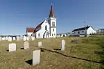 |
Fogo | 49.715 -54.2801 |
8143 | Municipal Heritage Building, Structure or Land | 2007 | |||
| M | Fortune Fishing Sheds Municipal Heritage Site |
|
Fortune | 47.0736 -55.8264 |
5866 | Municipal Heritage Building, Structure or Land | 2006 | |||
| M | George and Mary Lake House Municipal Heritage Site |
|
Fortune | 47.0743 -55.8279 |
5763 | Municipal Heritage Building, Structure or Land | 2006 | |||
| M | Victoria Hall Masonic Lodge 1378 Municipal Heritage Site |
|
Fortune | 47.0736 -55.8264 |
5963 | 1882 | Municipal Heritage Building, Structure or Land | 2006 | ||
| F | Tour de phare |
|
Fortune Bay | 47.4732 -55.4056 |
3903 | 1908 | Recognized Federal Heritage Building | 1989 | ||
| P | Buffett House Registered Heritage Structure |
|
Grand Bank | 47.1022 -55.7542 |
7779 | Registered Heritage Structure | 2007 | |||
| F | Dépôt d'appâts |
|
Grand Bank | 16 Lower Water Street | 47.1005 -55.75 |
2008 | 1948 | Recognized Federal Heritage Building | 2003 | |
| P | Fidelity Lodge 5 |
|
Grand Bank | 47.1023 -55.7559 |
1893 | 1905 | Registered Heritage Structure | 1989 | ||
| M | Fidelity Masonic Lodge 5 Municipal Heritage Building |
|
Grand Bank | 47.1023 -55.7559 |
7458 | 1905 | Municipal Heritage Building, Structure or Land | 2007 | ||
| M | Frazer Park Municipal Heritage Site |
|
Grand Bank | 47.101 -55.754 |
7459 | Municipal Heritage Building, Structure or Land | 2007 | |||
| P | George C. Harris House |
|
Grand Bank | 47.1007 -55.754 |
2195 | 1908 | Registered Heritage Structure | 1993 | ||
| M | George C. Harris House Municipal Heritage Building |
|
Grand Bank | 47.1007 -55.754 |
7460 | 1908 | Municipal Heritage Building, Structure or Land | 2007 | ||
| M | J. B. Foote House Municipal Heritage Building |
|
Grand Bank | 47.1024 -55.7586 |
7461 | 1908 | Municipal Heritage Building, Structure or Land | 2007 | ||
| P | Stoodley Fishing Stage |
|
Grand Bank | 47.0995 -55.7528 |
2026 | 1880 | Registered Heritage Structure | 2002 | ||
| M | Stoodley Fishing Stage Municipal Heritage Building |
|
Grand Bank | 47.0995 -55.7528 |
7462 | Municipal Heritage Building, Structure or Land | 2007 | |||
| P | The Thorndyke |
|
Grand Bank | 47.1007 -55.754 |
2196 | 1917 | Registered Heritage Structure | 1988 | ||
| M | The Thorndyke Municipal Heritage Building |
|
Grand Bank | 47.1194 -55.7532 |
7463 | 1917 | Municipal Heritage Building, Structure or Land | 2007 | ||
| P | Harmsworth Hall | 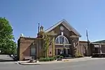 |
Grand Falls-Windsor | 49.0096 -55.5085 |
2560 | 1929 | Registered Heritage Structure | 1998 | ||
| M | St. Matthew's Presbyterian Church | 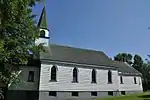 |
Grand Falls-Windsor | 48.9312 -55.6594 |
5022 | 1910 | Municipal Heritage Building, Structure or Land | 2005 | ||
| P | Greenspond Courthouse |
|
Greenspond | 49.0686 -53.5681 |
2074 | 1900 | Registered Heritage Structure | 1988 | ||
| P | Harding House |
|
Greenspond | 49.0686 -53.5675 |
1887 | 1890 | Registered Heritage Structure | 2002 | ||
| P | Hector Carter House, Henhouse, Fishing Shed and Property Registered Heritage Structure |
|
Greenspond | 49.0686 -53.5675 |
10636 | 1910 | Registered Heritage Structure | 2008 | ||
| M | Beaver Pond Municipal Heritage Site |
|
Harbour Breton | 47.477 -55.832 |
11962 | Municipal Heritage Building, Structure or Land | 2009 | |||
| M | Deadman’s Cove Municipal Heritage Site |
|
Harbour Breton | 47.467 -55.847 |
15369 | Municipal Heritage Building, Structure or Land | 2009 | |||
| M | Friar’s Cove Municipal Heritage Site |
|
Harbour Breton | 47.464 -55.797 |
15368 | Municipal Heritage Building, Structure or Land | 2010 | |||
| M | Gorman/Hynes House Municipal Heritage Site |
|
Harbour Breton | 47.472 -55.827 |
13794 | 1912 | Municipal Heritage Building, Structure or Land | 2009 | ||
| M | Gun Hill Municipal Heritage Site |
|
Harbour Breton | 47.489 -55.811 |
11963 | Municipal Heritage Building, Structure or Land | 2009 | |||
| M | Harbour Breton Landslide Monument Municipal Heritage Site |
|
Harbour Breton | 47.479 -55.806 |
13240 | Municipal Heritage Building, Structure or Land | 2009 | |||
| M | Hunt's Point Municipal Heritage Site |
|
Harbour Breton | 47.485 -55.802 |
12909 | Municipal Heritage Building, Structure or Land | 2009 | |||
| M | Man-of-War Brook Municipal Heritage Site |
|
Harbour Breton | 47.475 -55.8144 |
10832 | Municipal Heritage Building, Structure or Land | 2008 | |||
| M | Newman and Company Root Cellar Municipal Heritage Site |
|
Harbour Breton | 47.48 -55.802 |
15367 | Municipal Heritage Building, Structure or Land | 2010 | |||
| M | Newman’s Flagpole Rock Municipal Heritage Site |
|
Harbour Breton | 47.48 -55.8 |
13795 | Municipal Heritage Building, Structure or Land | 2009 | |||
| M | Red Head Municipal Heritage Site |
|
Harbour Breton | 47.459 -55.832 |
15366 | Municipal Heritage Building, Structure or Land | 2009 | |||
| M | Rocky Point Light Tower Municipal Heritage Site |
|
Harbour Breton | 47.479 -55.794 |
13796 | 1881 | Municipal Heritage Building, Structure or Land | 2009 | ||
| M | St. Bartholomew’s Memorial Stone Municipal Heritage Site |
|
Harbour Breton | 47.48 -55.814 |
13797 | Municipal Heritage Building, Structure or Land | 2009 | |||
| M | Sunny Cottage Municipal Heritage Building |
|
Harbour Breton | 47.4766 -55.8261 |
11950 | 1909 | Municipal Heritage Building, Structure or Land | 2008 | ||
| P | Sunny Cottage Registered Heritage Structure |
|
Harbour Breton | 47.4766 -55.8261 |
1937 | Registered Heritage Structure | 1988 | |||
| P | Truth Loyal Orange Lodge LOL 116 | 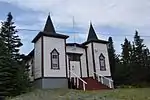 |
Herring Neck | 49.6471 -54.7619 |
2203 | 1904 | Registered Heritage Structure | 1986 | ||
| P | Brett House and Outbuildings |
|
Joe Batt's Arm-Barr'd Islands-Shoal Bay | 49.7296 -54.1733 |
2228 | 1879 | Registered Heritage Structure | 2003 | ||
| M | Brett Property Municipal Heritage Site |
|
Joe Batt's Arm-Barr'd Islands-Shoal Bay | 49.7296 -54.1733 |
8144 | Municipal Heritage Building, Structure or Land | 2007 | |||
| M | St. John Lodge Society of United Fishermen No. 11 Municipal Heritage Building |
|
Joe Batt's Arm-Barr'd Islands-Shoal Bay | 49.7253 -54.1789 |
10196 | 1916 | Municipal Heritage Building, Structure or Land | 2008 | ||
| M | Noah Chippett Stage/Twine Loft and Wharf Municipal Heritage Site |
|
Leading Tickles | 49.501 -55.468 |
7308 | Municipal Heritage Building, Structure or Land | 2007 | |||
| M | Old Catholic Cemetery Municipal Heritage Site |
|
Leading Tickles | 49.4947 -55.4573 |
8008 | Municipal Heritage Building, Structure or Land | 2007 | |||
| M | Old Church of England Cemetery Municipal Heritage Site |
|
Leading Tickles | 49.5035 -55.458 |
8006 | Municipal Heritage Building, Structure or Land | 2007 | |||
| M | Old Methodist Cemetery Municipal Heritage Site |
|
Leading Tickles | 49.5015 -55.4703 |
8007 | Municipal Heritage Building, Structure or Land | 2007 | |||
| M | Roland Chippett Stage Municipal Heritage Building |
|
Leading Tickles | 49.501 -55.468 |
7309 | Municipal Heritage Building, Structure or Land | 2007 | |||
| P | St. Anne's Church | 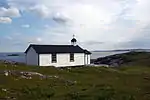 |
Little Fogo Island | 49.8117 -54.1207 |
2092 | 1873 | Registered Heritage Structure | 1995 | ||
| M | Long Island Consumers Co-op Store Municipal Heritage Building |
|
Lushes Bight-Beaumont-Beaumont North | 49.614 -55.678 |
7480 | 1957 | Municipal Heritage Building, Structure or Land | 2007 | ||
| M | Reddy Property Municipal Heritage Site |
|
Marystown | 47.1585 -55.1625 |
5380 | 1897 | Municipal Heritage Building, Structure or Land | 2005 | ||
| M | St. Gabriel's Hall Municipal Heritage Building |
|
Marystown | 47.1611 -55.1619 |
7277 | 1919 | Municipal Heritage Building, Structure or Land | 2006 | ||
| M | Piercey House Municipal Heritage Site |
|
Milltown-Head of Bay D'Espoir | 47.915 -55.7508 |
13798 | Municipal Heritage Building, Structure or Land | 2009 | |||
| P | Fishermen’s Union Trading Company Cash Store Registered Heritage Structure |
|
Musgrave Harbour | 49.4496 -53.9431 |
8145 | 1910 | Registered Heritage Structure | 2007 | ||
| P | Emma and Philip Templeman Property Registered Heritage Structure |
|
New-Wes-Valley | 49.2042 -53.5162 |
6297 | Registered Heritage Structure | 2006 | |||
| P | Alphaeus Barbour House |
|
Newtown | 49.2018 -53.5154 |
2108 | 1904 | Registered Heritage Structure | 1986 | ||
| P | St. Mark's Church |
|
Nippers Harbour | 49.7843 -55.8669 |
2109 | 1845 | Registered Heritage Structure | 1992 | ||
| P | Patrick Hayden Residence |
|
Petite Forte | 47.3954 -54.6683 |
5314 | 1889 | Registered Heritage Structure | 1997 | ||
| P | Bethany United Church |
|
Petites | 47.6199 -58.6303 |
2318 | 1859 | Registered Heritage Structure | 1994 | ||
| M | Hewlett House and Grounds Municipal Heritage Site |
|
Robert's Arm | 49.4838 -55.8418 |
5966 | 1937 | Municipal Heritage Building, Structure or Land | 2006 | ||
| P | Rose Blanche Lighthouse | 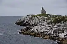 |
Rose Blanche | 47.6167 -58.6833 |
2095 | 1856 | Registered Heritage Structure | 2002 | ||
| P | Pickersgill Premises Registered Heritage Structure |
|
Salvage | 48.6833 -53.6333 |
2334 | 1914 | Registered Heritage Structure | 1997 | ||
| P | Fishermen's Union Trading Company Premises Registered Heritage Structure |
|
Seldom-Little Seldom | 49.6099 -54.185 |
15663 | 1912 | Registered Heritage Structure | 2009 | ||
| M | H.C. Grant Heritage Museum Municipal Heritage Building |
|
Springdale | 49.4966 -56.0703 |
5348 | 1920 | Municipal Heritage Building, Structure or Land | 2006 | ||
| P | H.C. Grant Heritage Museum Registered Heritage Structure |
|
Springdale | 49.4966 -56.0703 |
4017 | 1920 | Registered Heritage Structure | 2005 | ||
| M | Cape Chapeau Rouge Municipal Heritage Site |
|
St. Lawrence | 46.8905 -55.3754 |
3593 | Municipal Heritage Building, Structure or Land | 2005 | |||
| M | Cemetery for Priests and Religious Sisters Municipal Heritage Site |
|
St. Lawrence | 46.9214 -55.3774 |
5452 | Municipal Heritage Building, Structure or Land | 2005 | |||
| M | Iron Springs Mine Municipal Heritage Site |
|
St. Lawrence | 46.9862 -55.4173 |
3594 | Municipal Heritage Building, Structure or Land | 2005 | |||
| M | St. Cecilia Roman Catholic Cemetery Municipal Heritage Site |
|
St. Lawrence | 46.9257 -55.3922 |
8581 | Municipal Heritage Building, Structure or Land | 2005 | |||
| M | St. Lawrence Centennial Soccer Field |
|
St. Lawrence | 46.9224 -55.394 |
3554 | 1960 | Municipal Heritage Building, Structure or Land | 2005 | ||
| M | St. Matthew's Anglican Cemetery Municipal Heritage Site |
|
St. Lawrence | 46.925 -55.3911 |
8580 | Municipal Heritage Building, Structure or Land | 2005 | |||
| M | USS Truxtun and USS Pollux Historic Wreck Sites |
|
St. Lawrence | 46.8773 -55.4284 |
3436 | 1942 | Municipal Heritage Building, Structure or Land | 2005 | ||
| P | Dwyer House |
|
Tilting | 49.7056 -54.0585 |
2170 | 1890 | Registered Heritage Structure | 1990 | ||
| P | Lane House |
|
Tilting | 49.7081 -54.0653 |
2114 | Registered Heritage Structure | 1994 | |||
| F | Tilting |  |
Tilting | 49.7056 -54.0659 |
13153 | 1992 | LHN | 2003 | ||
| P | Martin Greene House and Outbuildings |
|
Tilting | 49.7023 -54.0639 |
2025 | 1910 | Registered Heritage Structure | 2003 | ||
| P | Pearce Foley House Registered Heritage Structure |
|
Tilting | 49.705 -54.0585 |
2296 | Registered Heritage Structure | 2002 | |||
| P | Tilting Registered Heritage District |
|
Tilting | 49.7081 -54.0653 |
2731 | 1960 | Registered Heritage District | 2003 | ||
| P | Ashbourne Longhouse |
|
Twillingate | 49.6554 -54.761 |
2308 | 1820 | Registered Heritage Structure | 1991 | ||
| M | Ashbourne Longhouse Municipal Heritage Site |
|
Twillingate | 49.6554 -54.761 |
16265 | Municipal Heritage Building, Structure or Land | 2007 | |||
| P | Ashbourne Office Registered Heritage Structure |
|
Twillingate | 49.6554 -54.761 |
12899 | Registered Heritage Structure | 2007 | |||
| P | Ashbourne Shop Registered Heritage Structure |
|
Twillingate | 49.6554 -54.761 |
12900 | Registered Heritage Structure | 2007 | |||
| M | Ephraim Jacobs House Municipal Heritage Site |
|
Twillingate | 49.6631 -54.7601 |
16266 | Municipal Heritage Building, Structure or Land | 2004 | |||
| M | Hart’s Cove General Cemetery Municipal Heritage Site |
|
Twillingate | 49.663 -54.759 |
16267 | Municipal Heritage Building, Structure or Land | 2009 | |||
| P | Hodge Brothers Premises Registered Heritage Structure |
|
Twillingate | 49.6571 -54.7748 |
5356 | 1914 | Registered Heritage Structure | 2006 | ||
| P | Loveridge House |
|
Twillingate | 49.65 -54.7702 |
2627 | 1907 | Registered Heritage Structure | 1993 | ||
| M | Loveridge House Municipal Heritage Site |
|
Twillingate | 49.65 -54.7702 |
16268 | Municipal Heritage Building, Structure or Land | 2007 | |||
| M | Old House Cove General Cemetery Municipal Heritage Site |
|
Twillingate | 49.649 -54.775 |
16269 | Municipal Heritage Building, Structure or Land | 2009 | |||
| F | Phare |
|
Twillingate | 49.689 -54.8 |
9675 | 1883 | Recognized Federal Heritage Building | 1989 | ||
| F | Résidence double |
|
Twillingate | 49.689 -54.7996 |
9625 | 1876 | Recognized Federal Heritage Building | 1989 | ||
| M | South Side United Church Municipal Heritage Building |
|
Twillingate | 49.6527 -54.7609 |
7279 | 1868 | Municipal Heritage Building, Structure or Land | 2006 | ||
| P | St. Peter's Anglican Church | 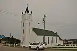 |
Twillingate | 49.6562 -54.7759 |
1902 | 1844 | Registered Heritage Structure | 1998 | ||
| P | St. Peter's Lodge SUF 12, Victoria Hall, Registered Heritage Structure |  |
Twillingate | 49.6497 -54.7723 |
5342 | Registered Heritage Structure | 2006 | |||
| M | St. Peter’s Anglican Cemetery Municipal Heritage Site |
|
Twillingate | 49.6547 -54.7783 |
16270 | Municipal Heritage Building, Structure or Land | 2009 | |||
| P | Twillingate Masonic Temple |
|
Twillingate | 49.6463 -54.7676 |
2172 | 1907 | Registered Heritage Structure | 1998 | ||
| M | Twillingate Masonic Temple Municipal Heritage Site |
|
Twillingate | 49.6463 -54.7676 |
16271 | 1907 | Municipal Heritage Building, Structure or Land | 2007 |
Notes et références
- Niveau de la désignation: F: Fédéral, P: Provincial, M: Municipal
- (fr) Répertoire canadien des lieux patrimoniaux : Manuel de normes de documentation, Annexe A : Vocabulaires contrôlés, p.59-78
(en) Canadian Register of Historic Places: Documentation Standards Handbook, Appendix A: Controlled Vocabulary, p.57-75
Annexes
Liens externes
- « Lieux patrimoniaux du Canada »
- « Annuaire des désignations patrimoniales fédérales », sur Parcs Canada
- (en) « Property Search », sur Heritage Foundation of Newfoundland and Labrador
 Portail de Terre-Neuve-et-Labrador
  Portail des lieux patrimoniaux du Canada
Cet article est issu de Wikipedia. Le texte est sous licence Creative Commons - Attribution - Partage dans les Mêmes. Des conditions supplémentaires peuvent s'appliquer aux fichiers multimédias.