Liste de points extrêmes du Tadjikistan
Cet article donne une liste de points extrêmes du Tadjikistan.
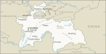
Carte du Tadjikistan
Latitude et longitude
- Nord : 41° 02′ 39″ N, 70° 26′ 45″ E La région la plus au nord est la région de Sughd.
- Est : 37° 24′ 29″ N, 75° 09′ 05″ E La région la plus à l'est est la région du Haut-Badakhchan.
- Ouest : 39° 18′ 14″ N, 67° 20′ 32″ E frontière avec l'Ouzbékistan
- Sud : 36° 40′ 16″ N, 71° 43′ 42″ E frontière avec l'Afghanistan
Le pays partage une frontière avec l'Ouzbékistan au nord et à l'ouest, et avec l'Afghanistan au sud[1].
Altitude
- Maximale : 7 495 m Pic Ismail Samani, qui est aussi le point culminant de l'ex-URSS[2],[3].
- Minimale : 300 m fleuve Syr-Daria[1].
Notes et références
- https://www.theodora.com/wfbcurrent/tajikistan/tajikistan_geography.html
- "Territorial and border issues". Ministry of Foreign Affairs of the Republic of Tajikistan, mars 2010. "The lowest spot of the country is on the height of 300 meters and the highest spot is on the height of 7495 meters above sea level.{...}on the South-East - Pamir (one of the highest spot of the Earth - peak Somoni, with the height of 7495 meters)"
- Stephen K. Batalden, Sandra L. Batalden (1997). The Newly Independent States of Eurasia Handbook of Former Soviet Republics (2 ed.). Oryx Press. (ISBN 0-89774-940-5)
- (en) Cet article est partiellement ou en totalité issu de l’article de Wikipédia en anglais intitulé « Extreme points of Tajikistan » (voir la liste des auteurs).
Liens externes
 Portail de la géographie
  Portail du Tadjikistan
Cet article est issu de Wikipedia. Le texte est sous licence Creative Commons - Attribution - Partage dans les Mêmes. Des conditions supplémentaires peuvent s'appliquer aux fichiers multimédias.