Kalibangan
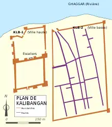
Kalibangan (hindi : काली बंगा) est un site archéologique d'Inde appartenant à la civilisation de l'Indus. Il est situé sur la rive gauche (sud) du Ghaggar (identifié par certains spécialistes comme le fleuve disparu Sarasvati[1],[2]), dans le district de Hanumangarh (municipalité de Pilibangān) dans l'État du Rajasthan, à 205 km de Bikaner. Il a été établi que son emplacement correspond au confluent des rivières Sarasvati et Drishadvathi[3].

| Kalibangan काली बंगा | ||
 Le tertre ouest appelé « Citadelle ». | ||
| Localisation | ||
|---|---|---|
| Pays | ||
| État | Rajasthan | |
| District | Hanumangarh | |
| Type | Cité | |
| Coordonnées | 29° 28′ 27″ nord, 74° 07′ 49″ est | |
| Géolocalisation sur la carte : Inde
| ||
C'est là que l'indianiste Luigi Tessitori (1887-1919) a d'abord identifié le caractère préhistorique et pré-maurya de la civilisation de l'Indus.
Le rapport des fouilles de Kalibangan a été publié dans son entièreté en 2003 par l'Archaeological Survey of India, 34 ans après la fin de celles-ci. Ce rapport conclut que Kalibangan était une capitale provinciale majeure de la civilisation de l'Indus. Kalibangan se démarque par ses autels du feu et son « plus ancien champ cultivé attesté »[4].
Références
- PB Calkins et Alam M, « India », Encyclopædia Britannica (consulté le ).
- (en) BB Lal, Purātattva, Indian Archaeological Society, , 1-5 p., « The Homeland of Indo-European Languages and Culture: Some Thoughts ».
- Jane McIntosh, « The Ancient Indus Calley : New Perspectives 6, ABC-CLIO, 2008, page 77.
- (en) BB Lal, Excavations at Kalibangan, the Early Harappans, 1960-1969, Archaeological Survey of India, , 17, 98 p..
Articles connexes
- Portail du monde indien
- Portail de l’Inde
- Portail de l’archéologie
