Borough londonien de Bexley
Le borough londonien de Bexley (« London Borough of Bexley ») est un borough du Grand Londres. Cette circonscription fut fondée en 1965 par fusion des districts du Kent, de Bexley, Erith et Crayford avec la moitié du district métropolitain de Chislehurst and Sidcup. Ce district compte plus de 219 000 habitants.
Pour les articles homonymes, voir Bexley.
| Borough londonien de Bexley | |
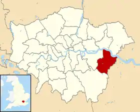 Carte de localisation dans le Grand Londres. | |
| Administration | |
|---|---|
| Pays | |
| Nation constitutive | |
| Comté | Grand Londres |
| Comté cérémonial | Grand Londres |
| Comté traditionnel | Kent |
| Statut | Borough |
| Gouvernement | Cabinet |
| Députés | John Austin, Derek Conway, David Evennett |
| Assemblée · Membre |
Bexley and Bromley James Cleverly |
| Maire | Val Clark |
| Code postal | DA, SE |
| Préfixe d'appel | 020, 01322 |
| Démographie | |
| Population | 228 000 hab. (2010) |
| Densité | 3 765 hab./km2 |
| Rang | 65e / 326 |
| Géographie | |
| Coordonnées | 51° 25′ 00″ nord, 0° 08′ 00″ est |
| Superficie | 6 056 ha = 60,56 km2 |
| Rang | 261e / 326 |
| Liens | |
| Site web | http://www.bexley.gov.uk/ |
Ce district est composé de :
- Albany Park
- Barnehurst
- Barnes Cray
- Belvedere
- Bexley
- Bexleyheath
- Blackfen
- Blendon
- Bostall
- Bridgen
- Coldblow
- Crayford
- Crook Log
- East Wickham
- Erith
- Falconwood
- Foots Cray
- Lamorbey
- Lessness Heath
- Longlands
- May Place
- North Cray
- North End
- Northumberland Heath
- Old Bexley
- Sidcup
- Slade Green
- Thamesmead
- Upper Belvedere
- Upton
- Welling
- West Heath
 Portail de Londres
Cet article est issu de Wikipedia. Le texte est sous licence Creative Commons - Attribution - Partage dans les Mêmes. Des conditions supplémentaires peuvent s'appliquer aux fichiers multimédias.